Skip to content
- Reconstruction of the Holocene stratigraphic architecture and 3D model

To reconstruct the subsurface architecture and the Holocene evolution of the Venice lagoon, a multidisciplinary approach will be adopted integrating Very High Resolution Seismic surveys with sedimentological and stratigraphic analyses on sedimentary cores. Interpretation of seismic data will allow tracing of the main reflectors that subdivide the different seismo-stratigraphic units. The recognition of the evolution in time and space of sedimentary bodies and depositional environments will follow the principles of the facies analysis through the use of sedimentological, paleontological, and C14 dating datasets available for the lagoon and neighbouring areas.
These analyses will allow to develop a state-of-the-art model of the Holocene stratigraphic architecture and evolution of the Venice Lagoon, and develops a simplified 3D geological model based on the relationship between the main depositional units and the potential compressibility of the sediments and according to their lithology, age, and depth, as input for the numerical simulation.
- Characterizing the geomechanical properties of the salt marshes deposits
Understanding the need of new sedimentation from the Venice Lagoon to keep pace with relative sea level rise requires a reliable knowledge of the mechanical properties of the Holocene deposits. In fact, together with sedimentation, autocompaction, i.e. the loss of soil thickness due to its own weight, is the main process governing the elevation of saltmarshes platforms. Saltmarshes deposits are extremely soft and autocompaction following new sedimentation can peak to more than 50% of the original sedimentation thickness.
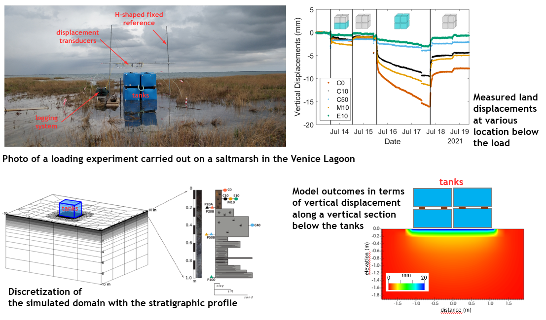
Several in-situ loading tests have been carried out on the saltmarshes in the Venice Lagoon over the last years. These tests would allow to provide a mechanical characterization more representative than classical lab tests (e.g. oedometric tests) as they do not require sampling of these smooth soils and involve much larger soil volumes. Displacement and groundwater pressure transducers deployed below the load at various depths have allowed to record the hydro-geomechanical response of the soil in space and time. The dataset will be interpreted using a 3-D mixed finite-element coupled flow-deformation simulator, implementing a nonlinear elasto-plastic constitutive relationship. The calibrated model using the obtained field data will allow to get reliable compressibility and hydraulic conductivity estimates for the deposits at the selected salt marshes.
- Historical and present land subsidence characterization
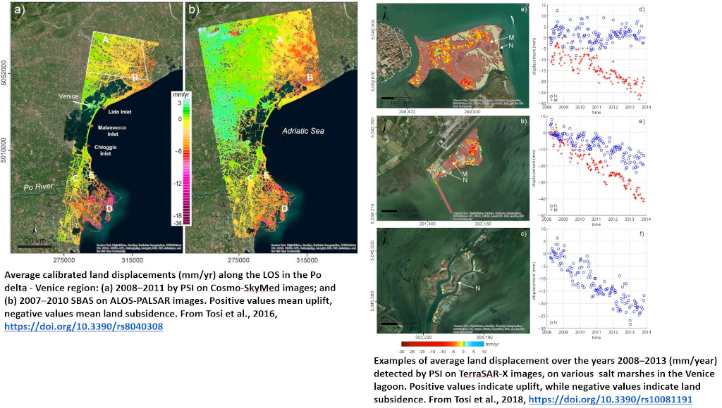
Of fundamental importance to the analysis of the processes responsible for the evolution of surface elevation in tidal morphologies of the Venice lagoon is land subsidence. Several previous studies have revealed significant spatial heterogeneity in vertical land movements within the lagoon, which, when combined with sea-level rise, poses varying threats to surface elevations.
A critical analysis will be conducted using recent Synthetic Aperture Radar (SAR)-based measurements from databases developed by previous studies and monitoring activities. These will be compared with subsidence monitoring data collected over past decades and the most reliable GPS/GNSS time series. Subsidence analysis from the 2015-2023 Sentinel-1 time series, available through the Veneto Region geoportal, and data from the 2018-2022 period from the European Ground Motion Service (EGMS) of Copernicus will help to spatially characterize regional and local land subsidence
These data will also be used to validate a 3D finite element (FE) numerical model capable of reproducing the evolution of the lagoon during the Holocene.
- Vulnerability assessment of Venice
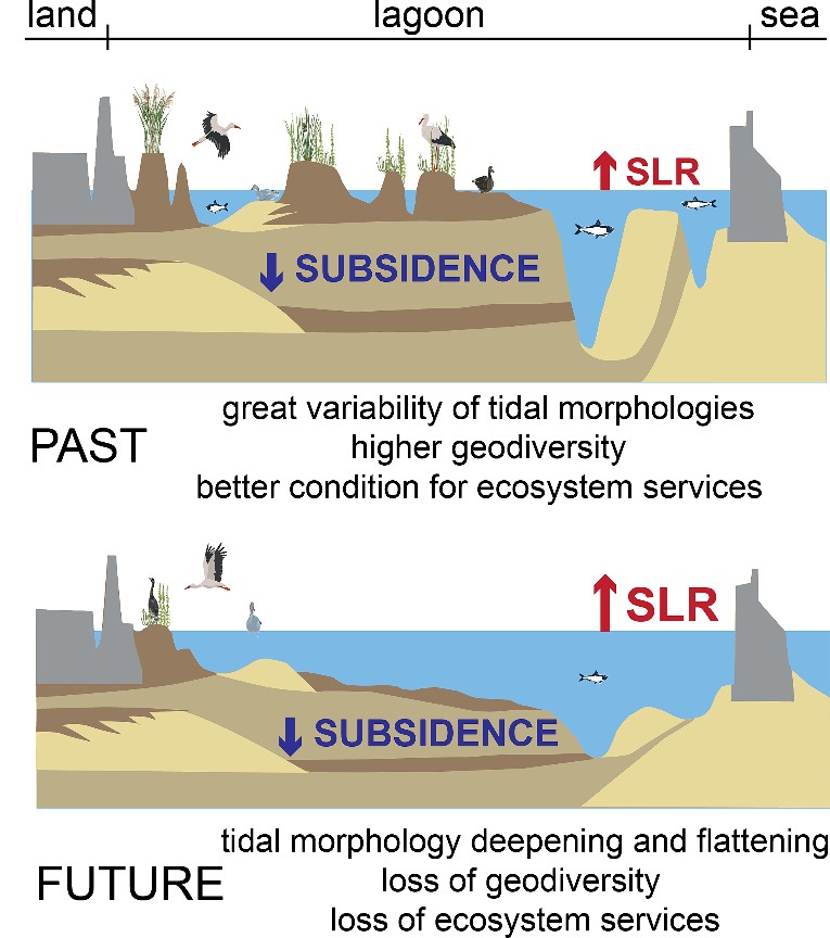
Loss of geodiversity leads to loss of ecosystem services
Now that the MoSE is operational, concern for Venice’s vulnerability has shifted to the survival of tidal morphologies that can no longer keep pace with RSLR and whose diversity (geodiversity) sustains the ecosystem services that make Venice’s lagoon landscapes so unique.
The new concept of vulnerability proposes the saltmarsh-tidal flat system as a continuum in which submerged and emerged morphologies are mutually dependent. Thus, not only the morphologies that are above mean sea level are sensitive to RSLR, but also the subtidal environments (Fig. 1). In addition, since recent studies highlight that the compaction of Holocene soft sediments cannot be neglected in the vertical accretion of coastal plains, the main subsurface units have been also included.
Relevant indicators describing sensitivity and hazards to RSLR, such as ground elevation above and below msl, morphological land variability, and subsurface architecture are combined with the results of numerical models in an index-based method to obtain an overall assessment of the vulnerability of the saltmarsh-tidal flat system.


